Completed Environmental Assessments
6th Concession Road/North Talbot Road
The City of Windsor has completed a Class Environmental Assessment to provide an improved 6th Concession Road/North Talbot Road corridor that will serve the needs of the transportation system and area growth for a 20-year period. The study addresses impacts on the adjacent arterial/collector road network and land uses, including consideration of pedestrian connections, bikeway connections, traffic calming, and drainage issues.
Banwell Corridor
The City of Windsor has completed a Class Environmental Assessment Study (Class EA) to investigate providing an improved transportation corridor along Banwell Road from Tecumseh Road East to the Windsor city limits at the Canadian Pacific Railway (CPR) tracks south of Intersection Road (approximately 2.7 kilometres), which will serve the needs of the City of Windsor and area growth through a staged program of improvements over the next 20 years. The study addresses the short- and long-term traffic impacts, the adjacent road network, provisions for cyclists and pedestrians, and improved public safety in accordance with the Windsor Area Long Range Transportation Study (WALTS) and the Essex Windsor Regional Transportation Master Plan.
Cabana/Division Road
The City of Windsor has completed a Class Environmental Assessment study to address capacity, safety and operational improvements along the Cabana/Division Road corridor. An Environmental Study Report (ESR) has been prepared. The ESR documents the activities conducted in Phase 1,2, and 3 of the Environmental Assessment.
Environmental Study Report:
Public Information Centre
There will be a Public Information Centre (PIC) held on May 3rd between 5pm and 7pm at Roseland Public School to discuss the possible road closures to Karen Street and Harcourt Street. See the link below for further details.
Central Box Study Area
The City of Windsor has completed a Municipal Class Environmental Assessment (Class EA) to provide short and long-term transportation network improvements to the Central Box Study Area in the City of Windsor to serve the needs of the transportation system, related infrastructure and area growth for a 20-year period. The study area is generally bound by Eugenie Street (north), Howard Avenue (east), West Grand/South Cameron Boulevard (south) and Dominion Boulevard (west).
Dougall Parkway/Sixth Concession
Downtown Transportation Strategy
The City of Windsor has completed a study to develop a sustainable strategy for a transportation system that supports Council's Strategic Vision for a vibrant and inviting Downtown Windsor, focusing on place-making and supporting active transportation choices, while taking into account existing and planned land uses.
Downtown Windsor Transportation Master Plan
Ontario Lottery and Gaming (OLG) in association with the City of Windsor and Windsor Casino undertook a Downtown Windsor Transportation Master Plan study to assess the longer-term traffic circulation and operational requirements to accommodate new developments in the downtown area. This study was conducted following the approved environmental planning process for Master Plans under the Municipal Class Environmental Assessment (EA) (2000), with opportunity for public input throughout the study. This process fulfilled the Class EA requirements for any Schedule B projects that are identified under this study.
Grand Marais Drain Concrete Channel
The Essex Region Conservation Authority (ERCA) and the City of Windsor retained Landmark Engineers Inc. to carry out an environmental assessment of the existing concrete-lined segment of the Grand Marais Drain. This Class EA aimed at exploring the potential for establishing improved connections between the communities on either side of the Drain and for making recreational, aesthetic, and habitat improvements within the channel corridor.
Grand Marais Drain Study and Environmental Assessment
The Essex Region Conservation Authority (ERCA) and the City of Windsor retained Landmark Engineers Inc. to carry out an environmental assessment of the Grand Marais Drain from Dougall Avenue to Walker Road. This Class EA aimed at defining a scope of channel improvements to the previously unimproved sections along the drain corridor through this reach.
Environmental Study Report:
- Section 1 to 5 - Project & Background Information (50 MB)
- Section 6 & 7 - Distribution Lists and Correspondence
- Section 8 - Archaeological Assessment
- Section 9 - Heritage Assessment
- Section 9 - Supplemental Letter to Heritage Assessment
- Section 10 - Soil and Sediment Quality Assessment
Addendum (August 2015):
- Addendum Figures
- Section 11 - Addendum Comments
- Section 12 - Ministry of Environment and Climate Change Consultation
- Section 13 - Geotechnical Reports (42 MB)
- Section 14 - Additional Lab Reports
Grand Marais Road Corridor Improvement (Howard Avenue to Walker Road)
As part of the City of Windsor's ongoing roadway system improvements, a section of Grand Marais Road East from Howard Avenue to Walker Road has been identified in the Windsor Area Long Range Transportation Study (WALTS) as needing operational and capacity improvements. These improvements may involve roadway upgrading and widening for additional traffic lanes and/or bicycle lanes, and associated traffic control improvements at key intersections for traffic calming. The purpose of this study is to evaluate alternative solutions for the identified transportation problems in the study area, leading to the selection of a preferred solution and ultimately a preferred design.
Howard Avenue
The City of Windsor has completed a Class Environmental Assessment study to address capacity, safety and operational improvements along Howard Avenue between Highway 3 and Division Road, the Dougall Parkway Interchange, and the South Cameron Boulevard/DRTP/Division Road Intersection Complex. An Environmental Study Report (ESR) has been prepared:
- Environmental Study Report Part 1
- Environmental Study Report Part 2
- Design Plate Index
- Plates 1 to 4
- Plates 5 to 8
- Plates 9 to 12
- Plates 13 to 16
Central Corridor Network - Transportation Review
The City of Windsor completed a preliminary review of the Central Corridor Network (CCN) Area in association with the Howard Avenue Corridor Improvements Study to identify transportation issues with the study area.
Kamloops Street
The City of Windsor in conjunction with Tru Land Developments has completed a Class Environmental Assessment Study in accordance with Phases 1 & 2 of the Municipal Class Environmental Assessment (EA) process. The purpose of the study was to establish the preferred design and alignment for the Kamloops Street Extension from Marentette Avenue easterly through the Southwind Subdivision to the existing cul-de-sac west of Calderwood Avenue.
Lauzon Parkway Improvements
A Class Environmental Assessment Study has been completed to address the future requirements for Lauzon Parkway improvements.
-
ESR Appendices
-
Design Plates:
The study has the following main components:
-
Lauzon Parkway from E.C. Row Expressway to County Road 42 (2.5 km)
-
Lauzon Parkway's extension to Highway 401 (3 km)
-
Lauzon Parkway's further extension to Highway 3 (2.5 km)
-
County Road 42 from Walker Road to the City/County boundary (5.5 km)
-
County Road 42 from the City/County boundary to County Road 25 (10 km)
-
The future East-West Arterial from Walker Road to 10th Concession Road/County Road 17 (5 km) - Addendum (Environmental Study Report - Addendum)
Lou Romano Water Reclamation Plant - Environmental Reports for New Generator
The City of Windsor with the assistance of Dillon Consulting Inc. has completed an Environmental Screening Report (ESR) under O. Reg. 116/01 and the Ontario Environmental Assessment Act for the replacement of an existing diesel generator at the Lou Romano Reclamation Plant. The new generator will serve as emergency back-up power, as well as being available for non-emergency use to generate and supply power during peak periods under the Provincial Global Adjustment Program. The emergency generator will also include a selective catalyst reduction system to improve the quality of exhaust emissions, as required to allow for non-emergency use.
-
Environmental Screening Report - Final - January 2018
-
Lou Romano Notice of Completion - Final - January 16, 2018
McDougall Street
The Ontario government, through the Ontario Lottery and Gaming Corporation (OLGC), is investing $400 million at Casino Windsor. Part of the investment is for a new hotel, entertainment complex and conference centre to be located to the west of the Casino between Pitt Street and Chatham Street. The Expansion Project includes:
- New 400-room hotel (23 storeys) complementing the existing hotel
- New 5,000-seat auditorium/theatre
- 100,000 square feet of convention space
As the proposed site between the Esplanade and McDougall Street is not large enough, the Expansion Project will require a reconstruction of McDougall Street from Riverside Drive to south of Chatham Street.
In order to address the treatment of McDougall Street, the City of Windsor, in conjunction with OLGC, has conducted a Schedule B project under the Municipal Class Environmental Assessment (Class EA) process, to confirm the need for any required modifications to McDougall Street and to identify the preferred solution.
The preferred McDougall Street solution was presented to the public at a Public Information Centre (PIC), held on August 16, 2005. Taking into consideration the problem being addressed, the assessment of planning alternatives and potential environmental effects, and the comments received from technical agencies and the public, the recommended plan for McDougall Street includes reducing the roadway to one northbound and one southbound lane between Pitt Street and Chatham Street to accommodate the Expansion Project. A request for public comment on the plan was advertised throughout the community; documents were made available; and resulting comments were received until October 31, 2005.
Online documentation, in portable document format (PDF):
- Study Commencement and PIC Notice (Published in the Windsor Star, August 8 & 9, 2005)
- Study Completion Notice (Published in the Windsor Star, September 30 & October 1, 2005)
- Preferred McDougall Street Improvement Plan
Provincial/Division Road
The City of Windsor has completed a Class Environmental Assessment study to address capacity, safety, and operational improvements along the Provincial/Division Rd. corridor. An Environmental Study Report (ESR) has been prepared. The ESR documents the activities conducted in Phase 1, 2, and 3 of the Environmental Assessment (EA) process.
- Notice of Completion (Published in the Windsor Star February 3rd, 2007)
- Table of Contents
- Environmental Study Report
- Figure 6.0 - Preferred Design Part 1
- Update to Figure 6, Sheet 5 of 11 (Provincial - Cabana SW Corner)
- Figure 6.0 - Preferred Design Part 2
Riverside Drive Pedestrian Crossings
The City of Windsor has completed a Class Environmental Assessment study of the Riverside Drive pedestrian crossings. The objective of this project is to evaluate the potential alternative solutions to a pedestrian underpass based on the demand for a dedicated pedestrian grade separation, the suitability of the proposed location(s) and the design constraints along the Central Riverfront.
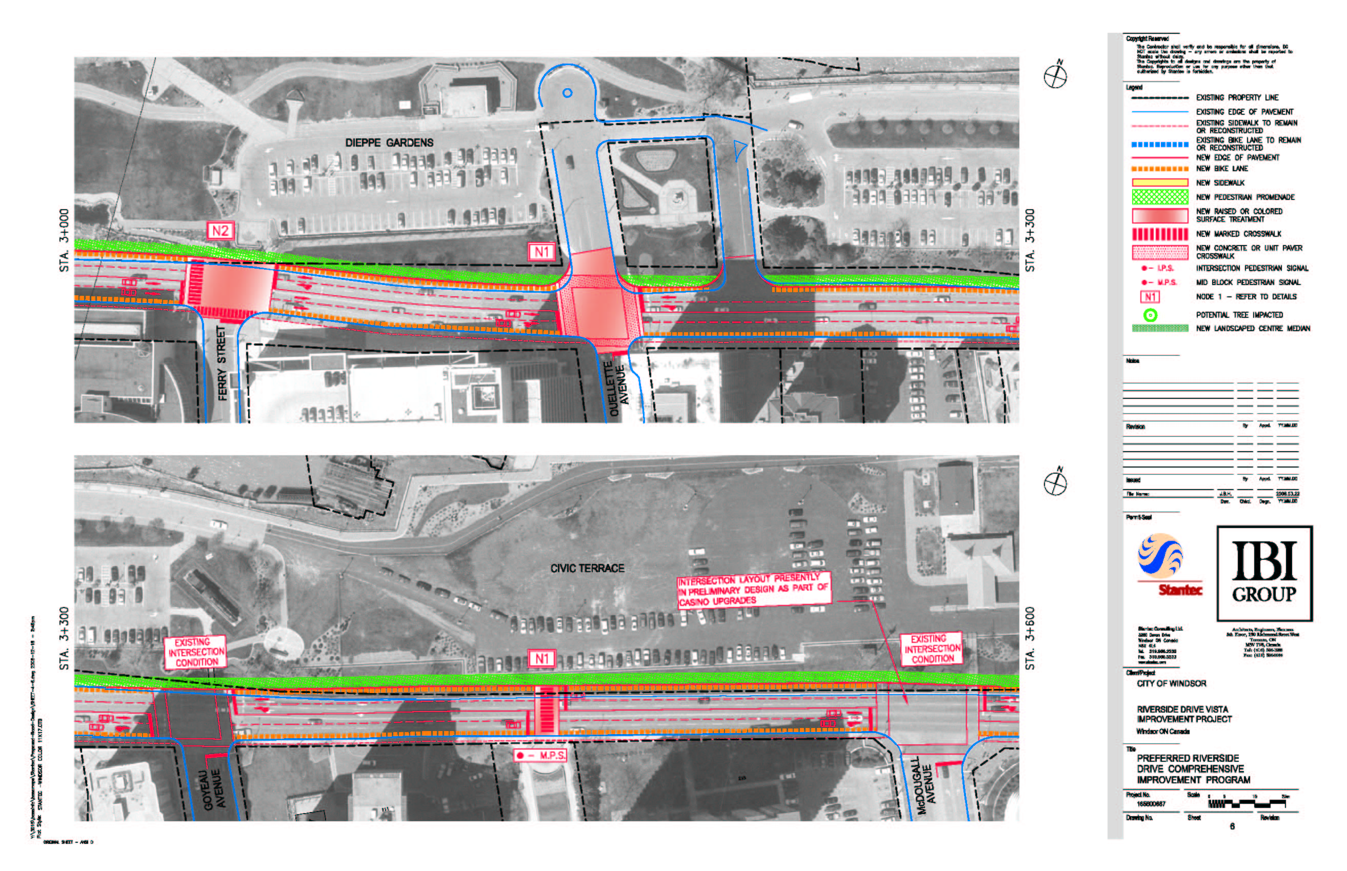
Riverside Drive Vista Improvement Project
The City of Windsor has completed a Class Environmental Assessment study to address capacity, safety and operational improvements along the Riverside Drive. The primary EA study area extends 16 kilometres from Rosedale Avenue just west of the Ambassador Bridge, east to the City border. A secondary study area for traffic analysis purposes was also established from Riverside Drive to Wyandotte Street along this 16 kilometre corridor. An Environmental Study Report (ESR) has been prepared.
Subsequent to the completion of this Environmental Assessment, detailed design commenced in 2018 for Phase 2A (from Ford Boulevard to St. Rose Avenue). Appendix A Preferred Design Concept Plans posted below for Buckingham to Thompson, Prado to Jefferson, Patrice Street, and St. Rose to Belleperche are superseded by detailed design plates. Riverside Drive Vista Phase 2A Reconstruction (Ford Boulevard to St. Rose Avenue), Property/Easement Requirements and Street Trees plans, as presented at PIC on May 23, 2019, which illustrated detailed design for proposed asphalt pavement, on-road bike lanes, driveway restoration, proposed sidewalk, and tree impacts, and property/easement requirements known at the time. The Sewer and Coastal Flood Protection Master Plan completed in November of 2020 further identified property/easement needs for sewer and barrier landform works.
Environmental Study Report:
- Notice of Completion
- Executive Summary
- Appendix B
- Section 1
- Section 2
- Section 3a
- Section 3b
- Section 3c
- Section 4a
- Section 4b
- Section 5a
- Section 5b
- Section 5c
- Section 6
- Section 6 Exhibits
- Section 7a
- Section 7b
- Section 7c
- Section 8
Design Guidelines:
- Part 1
- Part 2a
- Part 2b
- Part 2c
- Part 2d
- Part 3a
- Part 3b
- Part 4a
- Part 4b
- Part 5a
- Part 5b
- Part 5c
- Part 5d
- Part 5e
Appendix A:
- University to Patricia
- Sunset to Bridge
- Bridge to Cameron
- Cameron to Crawford
- Caron to Church
- Ferry to McDougall
- Glengarry to Louis
- Marentette to Pierre
- Hall to Lincoln
- Devonshire to Walker
- Montreuil to Cadillac
- Belleview to Strabane
- George to Rossini
- Janisse to Pillette
- Buckingham to Thompson
- Prado to Jefferson
- Patrice Street
- St. Rose to Belleperche
- Fairview to Lauzon
- Lauzon to Dieppe
- Dieppe to Riverdale
- Riverdale to Bertha
- Flora to Sandpoint Drive
- Florence to Clover
- Clover to Greenpark
- Greenpark to Jarvis
- Cora Greenwood to Lakeview Drive
- Ford Boulevard
- Thompson Boulevard
- Villaire to St. Louis
- St. Louis to Reedmere
Sewer and Coastal Flood Protection Master Plan
The City of Windsor completed the Sewer and Coastal Flood Protection Master Plan Class Environmental Assessment to better understand flooding issues within the city. The master plan took a system-wide approach to identify existing flood-prone areas for surface, basement, and coastal flooding and identified solutions, by priority, to address and reduce the risk of flooding during extreme rainfall events. The recommendations ultimately achieved the Mayor's 8-Point Plan to address flooding, which included source control measures, sewer system conveyance and storage improvements and coastal flood protection measures.
The master plan achieved the ultimate goal to set new standards and further support the successful long-term operation and maintenance of the city's storm and sanitary sewer systems.
Project Updates:
Sewer and Coastal Flood Protection Master Plan Report
St. Rose Stormwater Pumping Station
The City of Windsor has completed a Schedule 'C' Municipal Class Environmental Assessment (EA) for the St. Rose Stormwater Pumping Station. An Environmental Study Report (ESR) has been prepared. The recommended layout from the ESR features the pumping station below grade in the centre of the western portion of the park site with the electrical building and emergency generator at the south-west corner of the site.
Construction of the proposed infrastructure will increase the resiliency to flooding in this area and positively impact the community by protecting property, including municipal infrastructure, local transportation networks, and residential properties.
Tecumseh Road East Improvements
The City of Windsor has completed a Class Environmental Assessment study to address capacity, safety, and operational improvements along Tecumseh Road East between Jefferson Boulevard and Banwell Road. An Environmental Study Report (ESR) has been prepared.
Tecumseh Road West Corridor
Master Plan
Improvements to the Tecumseh Road West Corridor are required to address traffic safety concerns as well as to increase roadway traffic efficiency. The Master Plan process is described in the Class EA process document as being preferential where there are multiple problems in the study area and where improvements are to be implemented over an extended period of time.
Subway Structures at Wellington Avenue Environmental Study Report
This report together with the Tecumseh Road West Corridor Master Plan comprises the Environmental Study Report for the Tecumseh Road West Subway Structures at Wellington Avenue.
Addendum to Master Plan
The Tecumseh Road West Corridor Master Plan identified that Crawford Avenue to Church Street was substantially deficient with respect to traffic flow as a result of delays caused by rail traffic blocking traffic movements at each of the Essex Terminal (ETR) crossing and the Canadian Pacific Railway (CPR) crossing.
As per the Addendum, the decline in the number of rail movements at the CPR crossing at Tecumseh Road West has reduced the need for a grade separation at this location, but the exposure index still necessitates that some improvements be undertaken at the ETR and CPR crossings.
Tecumseh Road West (Janette to Crawford)
The City of Windsor initiated a Class Environmental Study in accordance with the Municipal Class Environmental Assessment (EA) process. The purpose of the study is to identify improvements to Tecumseh Road West from east of Crawford Avenue to Janette Street. These corridor improvements are proposed to support infrastructure renewal and the transportation needs through the study area, including operational and safety improvements.
Twin Oaks Drive/Railway Spur Line
The City of Windsor has completed a Class Environmental Assessment (EA) study to investigate environmental issues and alternatives for the extension of Twin Oaks Drive, construction of a rail spur track, relocation of Lachance Drain and municipal servicing. The City of Windsor requires the construction of a rail spur track extending northward from the Canadian Pacific Railway main track to the south side of the C.S. Wind property limits. The proposed alignment of the rail spur track crosses lands owned by the City. The City also intends to extend Twin Oaks Drive to the east of the railway spur track, relocate a portion of Lachance Drain and to provide site servicing to the adjacent properties. An Environmental Study Report (ESR) has been prepared.
Final Report & Appendices
- Cover Page and Report
- Notice of Completion
- Appendix A
- Appendix B
- Appendix C
- Appendix D
- Appendix E Part 1
- Appendix E Part 2
- Appendix E Part 3
- Appendix E Part 4
Previous Reports
Upper Little River Master Plan Environmental Assessment (ULREA)
The City of Windsor in conjunction with the Essex Region Conservation Authority (ERCA) and the Town of Tecumseh completed a Class Environmental Assessment Study in accordance with Phase 1 & 2 of the Municipal Class Environmental Assessment (EA) process. The purpose of the study is to document existing conditions and to recommend storm water management measures to protect existing resources as development continues in the upper reaches of Little River. In January 2023, the ULREA was completed and tabled for the 30-day review period in accordance with the Class Environmental Assessment process. Comments were received and addressed, and the report has now been adopted. The letter below summarizes the 30-day review period comments.
- Upper Little River EA Volume 1 - Report & Appendix A
- Upper Little River EA Volume 2 - Appendices B to N
- Notice of Completion
- April 24, 2023 Letter
Walker Road Corridor
The City of Windsor has completed a Class Environmental Assessment study to address capacity, safety and operational improvements along the Walker Road Corridor (Riverside Drive East to the City Limits) and Grand Marais Road East Corridor (Walker Road to Central Avenue). An Environmental Study Report (ESR) has been prepared.
Walker Road Corridor - Grand Marais Road East Improvements Preferred Design:
Other Studies (not initiated by the City of Windsor)
350 City Hall Square East, Suite 210
Windsor, Ontario N9A 6S1
Email: transportation@citywindsor.ca